Let me show you around
Golden
Jefferson County's seat, where Clear Creek comes out of the foothills. Brick and frame houses from the 1870s sit just west of downtown, ranches and hillside walkouts climb north toward North Table Mountain, and Washington Avenue is the main street.
Live listings on compass.com. Send me any address and I’ll tell you what to look for.
Winter sun
Which driveways stay iced in December and which back yards keep the afternoon. Worth knowing before you fall for a house.
See how the winter sun falls on Golden (opens in new tab)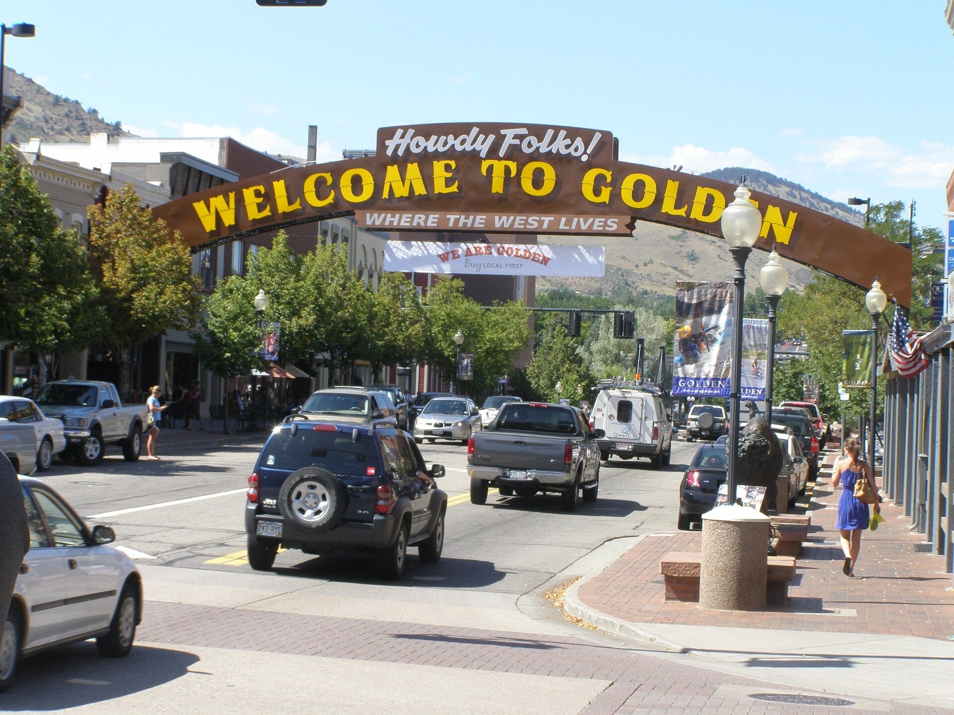
Living in Golden
Golden is its own city and the seat of Jefferson County, on the west side of the Denver metro. It sits on Clear Creek at the base of the Front Range, between Lookout Mountain and the two Table Mountains, with I-70 running through the southern part of town.
Territorial capital, then mills and a brewery
Golden City was founded on June 16, 1859, during the gold rush, and took its name from Thomas L. Golden. It was the capital of Colorado Territory from 1862 until 1867, when the job moved east to Denver. Mills, smelters and brickworks followed, and Coors has been brewing here since 1873. The Colorado School of Mines campus sits on the hill a few blocks south of downtown.
The houses, oldest by downtown and newer up the hill
The 12th Street Historic Residential District, bounded by 11th, 13th, Elm and Arapahoe Streets, is the most intact of Golden's early neighborhoods. Its houses are brick or wood frame from the 1870s to 1920, mostly plain local takes on the styles of the day, with a few two-story Italianates and some one-story cottages and bungalows. The Mines campus wraps around it to the south and west.
North of Highway 58, houses went up in three waves, each one farther north: the early 1900s, 1950 to 1960, and the mid-1990s. The older blocks at the south end of that stretch mix Folk Victorians, Gothic Revivals, Foursquares and bungalows, and mid-century brick ranches take over farther north. On the southwest slope of North Table Mountain the houses are mostly walkouts, built anytime from after World War II to now, and few were tract-built, so the styles vary. If a walkout basement is on your list, start on that hillside. Some streets in the middle of the north side are steeper than the city's own standard, so drive them in winter before you commit.
Washington Avenue and Ford Street
Washington Avenue is downtown's main street, lined with trees, planters, brick and ornamental lights. The Table Mountain Inn at 1310 Washington opened in 1925 as the Hotel Berrimoor, and the Grill & Cantina in its lobby runs a weekday happy hour and serves an asadero cheese appetizer lit on fire at the table. On Ford Street, the Golden Mill is a food hall in an old flour and feed mill a block north of the Coors brewery, with a creekside patio and a rooftop one. Bob's Atomic Burgers, at 1310 Ford, is a no-frills, old-fashioned burger counter and was a Westword writer's pick for one of the best burgers around in 2023.
Clear Creek and the trail west
Clear Creek runs through town, and its kayak course has a national reputation. The Clear Creek Trail's Gateway Segment, opened in 2021, covers 1.75 miles from downtown to Tunnel 1 along US 6.
Getting to Denver
US 6 crosses the south part of the city and curves north along the west side. Highway 58, the Golden Freeway, cuts east to west between 6th and 7th Streets, and Highway 93 heads north toward Boulder. RTD's W Line light rail starts at the Jefferson County Government Center-Golden station, which has parking, and runs 12.1 miles to Union Station.
Historic review, soils and floodplains
Golden has three local historic districts: 8th and 9th Street, 12th Street and East Street. Inside them, additions, alterations and new buildings need a Certificate of Appropriateness from the Historic Preservation Board, so expect review before you change the outside of a house. Demolition takes its own certificate and a $500 fee.
The western part of the north side has potentially expansive soils and bedrock. Since the mid-1990s, builders there have dug out below basement level and rebuilt the soil before construction, so older houses deserve a closer look. The warning signs are sudden cracks in brick or stone, a sagging roofline, and steps or a fireplace pulling away from the house. Cressman and Tucker Gulches have FEMA-mapped floodplains, and the city mapped Arapahoe Gulch on its own. Renovations there can face extra code requirements. The city's Public Works department can tell you a property's flood hazard, so ask before you offer on a house near a gulch.
FAQ
Is Golden part of Denver?
No. Golden is its own city and the seat of Jefferson County, on the west side of the Denver metro.
Can you take the train from Golden to Union Station?
Yes. RTD's W Line light rail runs 12.1 miles from the Jefferson County Government Center-Golden station, which has parking, to Union Station.
How old are the houses in Golden?
The 12th Street Historic Residential District has brick and frame houses from the 1870s to 1920. North of Highway 58, houses went up in three waves: the early 1900s, 1950 to 1960, and the mid-1990s.
Where are the walkout houses?
Mostly on the southwest slope of North Table Mountain, built anytime from after World War II to now.
Does Golden have historic districts?
Yes, three: 8th and 9th Street, 12th Street and East Street. Additions, alterations and new buildings there need a Certificate of Appropriateness from the Historic Preservation Board.
Are there soil or flood issues to know about?
The western part of the north side has potentially expansive soils and bedrock. Cressman, Tucker and Arapahoe Gulches have mapped floodplains, and the city's Public Works department can tell you a property's flood hazard.
Where do you eat downtown?
Washington Avenue is the main street, with the Table Mountain Inn's Grill & Cantina. On Ford Street there's the Golden Mill food hall and Bob's Atomic Burgers.